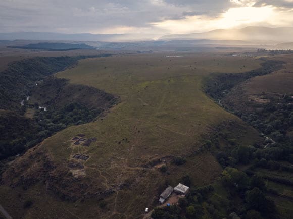
High-resolution UAV-based aerial survey of Dmanisis Gora, a Bronze-Age mega-fortress in Georgia, the South Caucasus, has revealed the extent of the large outer fortification system and settlement, which has few documented parallels in the region. The exceptional size of Dmanisis Gora helps add new dimensions to population aggregation models in Eurasia and beyond.
Fortress settlements in the South Caucasus appeared between 1500-500 BCE, and represent an unprecedented development in the prehistory of the regions.
Situated at the boundary between Europe, the Eurasian steppe, and the Middle East, the Caucasus region has a long history as a cultural crossroads with distinctive local identities.
In new research, archaeologists focused on Dmanisis Gora, a 60-80-ha fortress-settlement in Georgia of exceptional preservation and size.
“The fortress of Dmanisis Gora consists of a double-walled fortress core and a much larger outer enclosure with additional fortifications,” said Dr. Nathaniel Erb-Satullo from the Cranfield Forensic Institute at Cranfield University and his colleagues.
“Two steep-sided gorges, with a depth of 60 m in places, supplement the defensive walls.”
“Prior research noted that the site had an unusually large outer walled enclosure, but the site was not systematically mapped.”
The researchers used a DJI Phantom 4 RTK drone which can provide relative positional accuracy of under 2 cm as well as extremely high-resolution aerial imagery.
In order to obtain a highly accurate map of human-made features, they carefully checked each feature in the aerial imagery to confirm its identification.
To understand how the landscape of the site had evolved, the orthophotos were compared with 50-year-old photos taken by a Cold War-era spy satellite declassified in 2013.
That gave the scientists much needed insight into which features were recent, which were older.
It also enabled the team to assess what areas of the ancient settlement were damaged by modern agriculture.
All of those data sets were merged in Geographic Information System (GIS) software, helping to identify patterns and changes in the landscape.
“The drone took nearly 11,000 pictures which were knitted together using advanced software to produce high-resolution digital elevation models and orthophotos — composite pictures that show every point as if you were looking straight down,” Dr. Erb-Satullo said.
The team’s results showed that the Dmanisis Gora site was more than 40 times larger than originally thought, including a large outer settlement defended by a 1 km long fortification wall.
“The use of drones has allowed us to understand the significance of the site and document it in a way that simply wouldn’t be possible on the ground,” Dr. Erb-Satullo said.
“Dmanisis Gora isn’t just a significant find for the Southern Caucasus region, but has a broader significance for the diversity in the structure of large scale settlements and their formation processes.”
“We hypothesize that Dmanisis Gora expanded because of its interactions with mobile pastoral groups, and its large outer settlement may have expanded and contracted seasonally.”
“With the site now extensively mapped, further study will start to provide insights into areas such as population density and intensity, livestock movements and agricultural practices, among others.”
The team’s paper was published in the journal Antiquity.
_____
Nathaniel L. Erb-Satullo et al. Mega-fortresses in the South Caucasus: new data from southern Georgia. Antiquity, published online January 8, 2025; doi: 10.15184/aqy.2024.197